THERE WERE FIRES EVERYWHERE - SATURDAY, APRIL 20, 1963, CHAPTER 1
THERE WERE FIRES EVERYWHERE, SATURDAY, APRIL 20, 1963, by Joseph B. Ross Jr. (Copyright © 2022 by Joseph B. Ross Jr.)
CHAPTER 1 - Friendship Airport
Scoutmaster Raymond Robley scanned the area from elevated ground located on wooded Friendship Airport property about one-half-mile north of Dorsey Road.
Directly in front of him approximately 40 to 50 boy scouts of Troop 822, sponsored by the Linthicum Methodist Church, were setting up two-person army surplus pup tents along a 15 feet wide sandy soil fire break.
As the 11 to 15- year-old scouts struggled to set up their tents in a 20 mph wind with occasional 50 mph gusts, the wind would create little swirling tornados of sand along the fire breaks and the scouts had to cover their eyes for relief.
As Robley looked outward, he could see in the distance two large columns of smoke to his south and one large column of smoke somewhat closer to the north.
On this Saturday morning, April 20, 1963, the northeast was experiencing one of the greatest spring droughts on record. From Georgia to Maine there had been very little rainfall.
With no more than a couple drops of rainfall since April 1, the morning’s temperature was already registering in the mid-seventies and was expected to rise to the mid-eighties mark later in the day.

(Map indicates location of Troop 822 Scout Camp just north of Dorsey Road and location of early morning brush fires north of Stoney Run Road and near Elm Road. Saturday, April 20, 1963)
Maryland’s fire danger rating on this day was a Class 5 with a fire spread index of 200, extremely critical. It was the worst fire danger rated day in the state’s history.
Robley was aware of the drought and at the troop meeting the night before at the church, he urged all scouts to bring old-used-plastic liquid dish soap “squeeze” bottles filled with water to use as “make-shift” fire extinguishers for Saturday’s bivouac.
Around 10 am, Robley formed the troop for the morning’s ceremonial raising of the colors and afterwards reminded all of the scouts to keep an eye out for fire.
As the U.S. Flag flapped continuously and the flag pole, a tall thin ax-trimmed-downed tree, shook from the gusts of wind, Robley pointed to the columns of smoke and reminded everyone to be cautious.
He stated that there would be no camp fires until dusk and all fires would be small and made in one-foot deep holes within the sandy fire breaks.
Brush fires in the fields and woods surrounding the airport were not uncommon. Three years earlier, a fast-moving fire burned in the same area as the camp.
The fire would consume 800 acres as did a fire in a nearby area in 1953.

(Above an airport Crash Truck is being utilized to combat an 800 acre brush fire on the south side of the airport on 3/17/59. Sixteen AACo. engines, two additional from each Baltimore City, Baltimore County, and Howard County responded to assist. Photo - Doegen-Helfrich Collection)
As a result of the 1959 fire and to get a better handle on future fires, bulldozers had constructed fire breaks throughout the acres of woods and sage fields surrounding the small but growing international airport.
Anne Arundel County’s sandy soil made an excellent break when the ground cover was cleared. There was a little island of flat ground cover between two of the breaks, about 400 yards west of Cemetery Road (Old Telegraph Road) and it was this site that Robley selected for the camp.
The large column of smoke that Robley saw in the north was a large brush fire that had been burning since 5 am.
Firefighters from the Linthicum, Ferndale, Brooklyn, Glen Burnie and the Marley VFDs with fire engines, 4-wheel-drive jeeps and brush vehicles (many converted Army surplus Dodge power-wagons) were working together to suppress the fire.
Airport FD firefighters joined in with a fire engine and converted Army (firefighting) halftracks and all were doing their best to catch up with the running fire.

(Linthicum VFD, Company 32's Engine 324. A '52 Ford 500 GPM pumper with a 500 GWT was the first engine out to respond on brush fires. Note the 4 Indian Tanks mounted on the side running board. Photo - Tom German)
Firefighters with five gallon metal “Indian Tanks” strapped to their backs, like knapsacks, operated double-action-piston-hand-pumps with nozzles to attack the flanks of the fire. Others used rakes and shovels to smother the fire with dirt.

(A citizen with an Indian Tank helps firefighters battle a large brush fire in Brandon Shores during the early 1950s. Photo - credit to the photographer)
In areas accessible to engines and four-wheel-drive vehicles, firefighters maneuvered hose lines around trees and thick brush to apply water in greater quantities and at higher pressures. As firefighters would gain control, the wind would gust, shift, and move the head of the fire somewhere else.
The first fire burned along the east side of the Pennsylvania RR tracks between Stoney Run Road and Route 46 (todays I-195).
The second fire consisted of 200 acres in a heavy wooded area in what are today the airport’s north cargo complex and the tank farm east of Elm Road and south of Aviation Boulevard.
At the time the boulevard was named Camp Meade Road (also known to locals that lived around the airport during that time as the “State” Road).
Joseph Angyelof remembers the fire. An airport firefighter since August, 1962, he was also an active volunteer fire officer/firefighter with the Earleigh Heights VFD, Company 12.
When Angyelof arrived at the airport employee’s parking lot that morning, he met fellow firefighters Carroll Bunker and Melvin Smith. Angyelof would later say,“From the parking lot, a column of smoke was visible and the familiar odor of burning brush was evident.
When Assistant Chief Thomas Bolton pulled in, he asked us if we were ready for a busy day.” Bolton, an active volunteer fire officer/firefighter with the Laurel VFD in Prince Georges County worked part-time for the Maryland Forestry Service.
(Chief Tom Bolton above, commanding a drill at the airport circa 1970s)
Bolton and Angyelof had both been busy fighting several brush and woods fires throughout the week for their local departments.

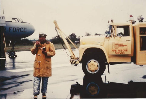
(Friendship International Airport Crash Station located at the end of the middle/observation deck pier. L-R 1946 International/John Bean engine and two airport crash/rescue trucks. circa 1960. Photo - Courtesy of Joseph MacDonald)
Angyelof was assigned as driver/operator on one of the two surplus military half-tracks converted to fire engines owned and operated by the airport.
The yellow-painted half-tracks were equipped with four-wheel drive, a 1,000 gallon water tank, a 250 gallon per minute (gpm) pump and a reel of 100 feet of one-inch booster (hard rubber) line hose.
The half-track had a large roller installed on the front bumper which allowed the unit to push over small trees.
Just to be on the safe side and mainly to protect personnel from being overrun by a shifting running wildfire, Angyelof wisely placed 100 feet of one-and-a-half-inch attack hose with attached nozzle on the unit.
Brush firefighting tactics can be tricky. It’s not wise to approach or put apparatus in the path of the brush fire’s head, which is the leading edge of a moving fire. Unexpected wind shifts make this decision all the more difficult.
A less dangerous approach is from the flanks or sides of the fire or from the blackened area that has already been burned.
Angyelof would later say, “The tactic was to drive the half-track up wind from a fire line, park the vehicle and extinguish what fire could be reached within a 100 feet radius of the vehicle.” And he would do this by himself.
Working the brush fire near Elm Avenue that morning and after refilling the water tank several times at a nearby fire hydrant, Angyelof found some help.
He came across two young volunteers from the Ferndale VFD that were carrying Indian Tanks that were now empty. Angyelof said, “They eagerly agreed to join my effort and we spent the next five to six hours working the fires.”
All day the crew worked the fires on the airport property and never left. Angyelof said, “It was good that we stayed at the airport, the half-tracks were slow with a top speed of only 30 miles-per-hour.
The half-tracks rattled and made so much noise that it made them tough to drive. I’m glad we kept them off of the main roads.”
Back at Troop 822’s campground, scouts finished their camp duties and broke out into small groups hiking and exploring the near-by fields and Pine covered woods, a few walked to the top of a hill where there was a small cemetery.
As the more curious members read the information etched on the tombstones, others looked south to see the columns of smoke that Robley had pointed out earlier.
The column of smoke to the southwest was still about the same size, the column further south was becoming larger.
The smaller plume was a brush fire located between the rural communities of Harmans and Severn on the west side of the Pennsylvania Railroad tracks in an area known as the Clay Banks.
Surrounding the Clay Banks, an old gravel pit located near a large pond where the residential development of Harman Woods is located today, was a raging brush fire.
Hearing siren after siren most of the morning, the scouts located on the hill could see the intersection of Dorsey and Camp Meade roads.
Fire engine after fire engine, jeeps, water tank trucks, brush vehicles, a jeep pulling a small trailer with a water tank, were all going through the intersection at different intervals and times with blinking red and white lights, and sirens.
Some of the vehicles were headed north, some south, others west as another brush fire had started up along the eastside of Washington Boulevard in Elkridge.